


The development of customized software allows the creation of several platforms for sampling, processing, and analysis of results.
From the definition, it is possible to conclude that every GIS uses software to enable the consultation, maintenance, and visualization of the graphic and alphanumeric data constant in the system, and also of software for management and storage of information, that is, a database manager.
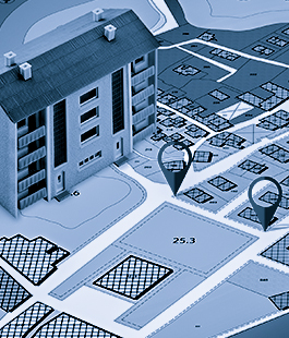
The Georeferenced Information Systems (GIS) should be understood as a set of programs, equipment, methodologies, data and people (users) perfectly integrated, in order to make the collection, storage, processing, and analysis of georeferenced data possible, as well as the production of information derived from its application.
GISs have their development associated with advances in Cartography, Computer Graphics, and Geography, especially those resulting from computerization and new resources provided by the introduction of computers and database managers.
A geographic information system requires the development of a geoinformation solution project by an interdisciplinary team that will contribute to the success of the execution of the services.
A geoinformation solution project involves the execution of activities in a systematized way with well-defined milestones, which allows the designer to plan each activity and execute it within a sequence in which it begins with the knowledge of the user, determining their needs and tasks, raising questions that can be answered through spatial analysis – which is one of the ways to determine the needs for geographic information –, describing the required geographic information to meet the user’s needs, until it is possible to close the cycle by determining the entities or classes of the geographic database and their attributes, their scales, and the design of the geographic database.

Engefoto has a highly qualified information technology staff, with computer engineers, systems analysts, programmers, and several professionals specialized in geoprocessing, with proven capacity in multi-platform solutions to meet various development standards, including desktop systems and Web applications.
It also stands out as an ESRI_Partners company.
It performs the complete fulfillment of your demand: data collection, processing, analysis, storage and availability in on-premise, web or mobile systems, training, and technical support.

Managing, supervising and overseeing of works, public concessions and enterprises.